During the Korean War, the Far East Air Force (FEAF) operated numerous air bases in Korea, many of which were former Japanese airfields upgraded and expanded by the United States. These air bases were designated with a “K” number to prevent confusion among locations, as the spelling of Korean locations on maps varied greatly, and villages had both Korean and Japanese names.
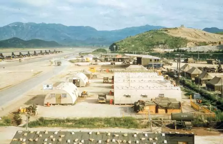
It is possible that the status of some of these locations changed during the war, such as an airfield being redesignated as an air base. In addition to the main air bases, the FEAF also established scores of auxiliary and emergency airstrips, which were designated with an “X-.” For example, X-83 was one of the auxiliary and emergency airstrips established during the Korean War.
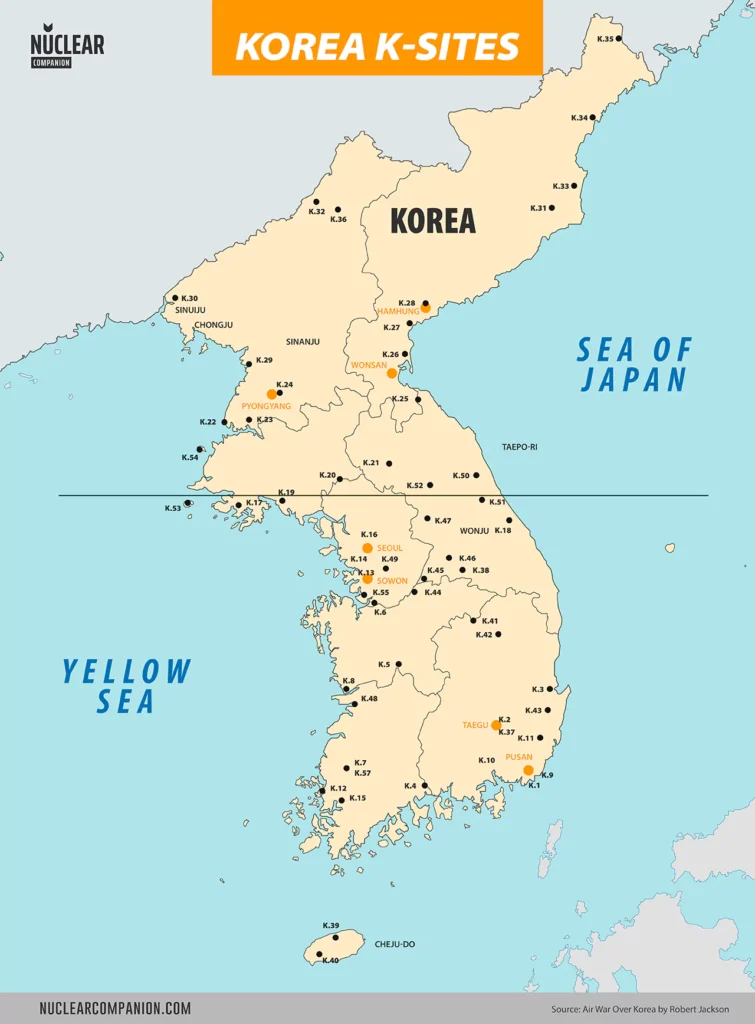
K-Sites code list
| Code | Name | Location | Current name | Coordinates | Remarks |
|---|---|---|---|---|---|
| K-1 | Pusan West Air base | South Korea | Gimhae Air Base | 35°10′46″N 128°56′18″E | |
| K-2 | Taegu Air base | South Korea | Daegu International Airport | 35°53′39″N 128°39′32″E | |
| K-3 | P'ohang Airdrome | South Korea | Pohang Gyeongju Airport | 35°59′16″N 129°25′13″E | |
| K-4 | Sachon Airdrome | South Korea | Sacheon Airport | 35°05′18.75″N 128°04′13.33″E | |
| K-5 | Taejon Airdrome | South Korea | Decommissioned | 36°21′28.8″N 127°23′42″E | |
| K-6 | P'yong Taek Airdrome | South Korea | Camp Humphreys | 36°57′38.4″N 127°02′01″E | |
| K-7 | Kwangju Airdrome | South Korea | Gwangju Airport | 35°07′35″N 126°48′32″E | |
| K-8 | Kunsan Air base | South Korea | Kunsan Air Base | 35°54′13″N 126°36′57″E | |
| K-9 | Pusan East Air Base | South Korea | Decommissioned | 35°10′10″N 129°07′54″E | |
| K-10 | Chinhae Air base | South Korea | Jinhae Airport | 35°08′28″N 128°41′45″E | |
| K-11 | Urusan Air Base (Ulsan) | South Korea | Ulsan Airport | 35°35′36″N 129°21′06″E | |
| K-12 | Mangun Airdrome | South Korea | |||
| K-13 | Suwon Air base | South Korea | Suwon Air Base | 37°14′08″N 127°00′34″E | |
| K-14 | Kimpo Air base | South Korea | Gimpo International Airport | 37°33′29″N 126°47′26″E | |
| K-15 | Mokp'o Airdrome | South Korea | Mokpo Airport | 34°45′32.06″N 126°22′47.54″E | |
| K-16 | Seoul Air Base | South Korea | Seoul Air Base | 37°26′45″N 127°06′50″E | |
| K-17 | Ongjin Airdrome (Oshin) | North Korea | Ongjin Airport | 37°55′51.70″N 125°24′54.30″E | |
| K-18 | Kangnung Airdrome (Koryo) | South Korea | Gangneung Air Base | 37°45′12″N 128°56′37″E | |
| K-19 | Haeju Airdrome (Kaishu) | North Korea | Haeju Airport | 38°00′23.60″N 125°46′43.80″E | |
| K-20 | Sinmak Airdrome | North Korea | |||
| K-21 | P'yonggang Airdrome | North Korea | |||
| K-22 | Onjong-Ni Airdrome | North Korea | Onchon Air Base | 38°54′34.20″N 125°13′56.00″E | |
| K-23 | P'yongyang Airdrome | North Korea | Pyongyang Air Base | 39°02′N 125°47′E | |
| K-24 | P'yongyang East Airdrome | North Korea | Mirim Airport | 39°0′35″N 125°50′50″E | |
| K-25 | Wonsan Air base | North Korea | Kalma Airport | 39°9′59″N 127°29′3″E | |
| K-26 | Sondak Airdrome | North Korea | Sondok Airport | 39°44′50.40″N 127°28′28.60″E | |
| K-27 | Yonpo Airdrome | North Korea | Yonpo Air Base | 39°47′26″N 127°32′7″E | |
| K-28 | Hamhung West Airdrome | North Korea | |||
| K-28 | Sinanju Airdrome | North Korea | |||
| K-30 | Sinuiju Airdrome | North Korea | Sinuiju Airport | 40°05′11.10″N 124°24′25.20″E | |
| K-31 | Kilchu Airdrome (Kisshu) | North Korea | |||
| K-32 | Oesichon-Dong Airdrome | North Korea | Manpo Airport | 41°08′24.70″N 126°21′26.40″E | |
| K-33 | Hoemun Airdrome (Kaibun) | North Korea | Orang Airport | 41°25′45″N 129°38′54″E | |
| K-34 | Ch'ongjin Airdrome (Seishin) | North Korea | Sungam Ni Airport | 41°40′27.40″N 129°40′35.50″E | |
| K-35 | Hoeryong Airdrome (Kainsei) | North Korea | |||
| K-36 | Kanggye #2 Airdrome | North Korea | |||
| K-37 | Taegu West Air Base (Taegu No. 2) | South Korea | Camp Walker | 35°50′11″N 128°35′25″E | |
| K-38 | Wonju Airdrome (Winju) | South Korea | Wonju Airport / Hoengseong Air Base | 37°27′33″N 127°58′37″E | |
| K-39 | Cheju-Do Airdrome | South Korea | |||
| K-40 | Cheju-Do Airdrome | South Korea | Alddreu Airfield | 33°12′18″N 126°16′12″E | |
| K-41 | Ch'ungju Airdrome | South Korea | |||
| K-42 | Andong Airdrome | South Korea | |||
| K-43 | Kyongju Airdrome | South Korea | |||
| K-44 | Changhowon-Ni Airdrome | South Korea | |||
| K-45 | Yoju Airdrome (Yoido) | South Korea | |||
| K-46 | Hoengsong Airdrome | South Korea | Wonju Airport / Hoengseong Air Base | 37°27′33″N 127°58′37″E | |
| K-47 | Ch'unch'on Airdrome | South Korea | Camp Page | 37°53′6″N 127°43′45″E | |
| K-48 | Iri Airdrome | South Korea | |||
| K-49 | Seoul East Airdrome | South Korea | |||
| K-50 | Sokcho-Ri Airdrome | North Korea | Sokcho Airport | 38°08′33″N 128°35′54″E | |
| K-51 | Inje Airdrome | South Korea | |||
| K-52 | Yanggu Airdrome | North Korea | |||
| K-53 | Paengnyong-do Airfield | South Korea | Not completed | ||
| K-54 | Konsong Airfield (Cho-do) | South Korea | Not completed | ||
| K-55 | Osan-ni Air base | South Korea | Osan Air Base | 37°05′26″N 127°01′47″E | |
| K-56 | Yangyang Emergency Strip | South Korea | Not completed | ||
| K-57 | Kwang-ju Air base | South Korea |
Key to Korean place-name endings
-bong = Mountain -Chaing = river
-chon = river
-dan = point
-do island
-dong = village, town
-gang = river
-gap = point
-get = point
-hang = harbor
-Ho = river
-kaykio = strait
-kundo archipelago
-li = villiage, town
-man = bay
-ni = village, town
-ri = village, town
-saki = point
-san = mountain
-Shan mountain
-shima island
-shoto archipelago
-tan = point
-Tao = island
-to-island
-tong village, town
-tu = point
Further reading
- Boeing B-29 Superfortress Units of the Korean War (1950-1953)
- Known B-29 Superfortress Losses in Korea (1950-1953
- The B-29’s Campaign in the Korean War: A chronology
Bibliography
- The B-29 Superfortress: A Comprehensive Registry of the Planes and Their Missions by Robert A. Mann
- Korean War Order of Battle: United States, United Nations, and Communist Ground, Naval, and Air Forces, 1950-1953 by Gordon L. Rottman
- Mustangs Over Korea: The North American F-51 at War 1950-1953 by David R. McLaren